 |  | |||
| 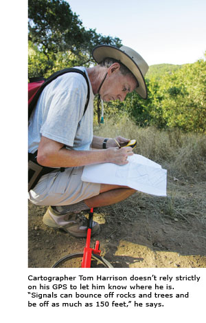
Putting California on the Map When it comes to navigating parks, forests and wilderness areas, hikers and bikers throughout California have come to rely on the directions they receive from Tom Harrison(M.A., '85). The cartographer has a reputation for making what one park official describes as "the Cadillac of maps." Harrison specializes in maps of California's parks, forests and wilderness areas. "The last maps of these areas were made in the mid-'80s," he explains, pointing out that while trailheads, water and roadways undergo frequent change, government-issued maps do not. "Parks aren't in the business of making maps," Harrison says. They lack the time and resources to do what he does: create full-color topographic maps, complete with shaded relief to highlight elevation. "Tom cares about specific details and he's very accurate," says Ellen McElhinny, a lecturer in geography and environmental studies. She carries Harrison's maps on her hikes, as do many of her students. Part of the maps' appeal lies in the details, from the location of drinking water to specifics on where dogs, bikes and horses are permitted. Harrison saw the potential market for his maps while working as a park ranger in Marin County -- a job he quit to develop his mapmaking skills in SF State's graduate program in geography. "The faculty have high standards. They don't tolerate sloppy work," he says, pointing to his advisor, Professor Emeritus Hans Meihoefer. Harrison launched his business with a single map of Angel Island. Today, after two decades of fieldwork, he sells maps of 48 popular California backcountry spots. Each starts with the same process. With the aid of a measuring wheel, topographical map, digital voice recorder and Global Positioning System, Harrison calculates each 1-foot increment from trail junctions, noting his measurements digitally. At home he refers to his notes and makes changes on computer-generated maps. He sells about 75,000 maps each year to individuals, parks and outdoor-focused retail outlets. The cartographer seems to have an innate sense of direction. "My wife [Barbara Harrison(M.A., '85)] noticed that I never turn on lights," he says. "I always seem to know where I am." For more information: www.tomharrisonmaps.com
| |||